Monday, October 29, 2012

Monday October 29

Having finished our last post just yesterday saying I had no idea when we would be able to do another, here we are already!  Each little place and roadhouse we’ve been through has had a signal and there have even been random moments in what seemed like the middle of nowhere when the phone has sprung into life and pinged madly as messages and emails arrived!  The only conclusion we could come to was that there was a mine site lurking out there somewhere.

It seems like longer ago than yesterday morning that we left Kalgoorlie, but that is probably just because we have come quite a distance, arriving here in Eucla a day sooner than expected and as tomorrow morning will see us across the border into SA (it is only 13km away), I thought we should do out last blog entry from WA whilst we are still here!

From Kalgoorlie we travelled south to Norseman, another gold mining area, before turning right and starting the trek east.  The road down to Norseman continued through the Great Western Woodlands and we really enjoyed the beautiful eucalypts we were seeing – lots and lots of gloriously flowering Coral Gums (back to the Western Flora photos to find these!), Gimlets, Salmon Gums and absolutely heaps of Goldfields Blackbutts, which are lovely trees – the contrast between the smooth white trunks and the rough, black bark of the lower part of the trunk is fantastic.

Goldfields Blackbutts.

A large expanse of the Woodlands continued east to Balladonia and from there they become a narrow strip south of the Eyre Highway, although the landscape continued to be far more vegetated than we had expected (here I go again – more things that we didn’t expect!), going into areas of mallee and mulga and back to larger trees and on the higher ground. 

We spent last night at a roadside stop between Balladonia and Caiguna and because the sun is now rising so early (about 5.20am) and WA doesn’t have daylight saving, we are awake at sparrow’s.  This is very good for travelling – we were on the road by 6.45 and even though the country through which we were travelling was very interesting, there was nowhere we wanted to stop, so we kept going.

One thing that amazed us (or should I say another one – we are always being amazed) was that as we approached Madura, which is about two thirds of the way to the border, we suddenly found ourselves at the top of Madura Pass which took us down to the Roe Plains below.  We had always assumed the road across the whole of the Nullarbor was very flat – demonstrates once again the danger of assuming anything!  The Nullarbor is, at this stage, north of the escarpment and the Hampton Tablelands

My useful map of the Nullarbor told us one very interesting thing at this point – Madura Station was settled in 1876 and was used to breed horses for the British Army in India.  Seems bizarre, although growing up in this sort of country would have made all horses very tough indeed!  It also informed us that the Nullarbor, which was once part of the ocean floor, is the world’s biggest, flattest piece of limestone, covering an area of approximately 200,000 square kilometres and up to 300 metres thick.  Learning all the time!

The road  across to the next roadhouse, Mundrabilla and beyond travelled across the Roe Plains below the limestone escarpment - the edge of that huge piece of limestone I guess.  Stopped a few kilometres after Mundrabilla for lunch and Murray went off to get a photo of the escarpment without the road sign in the way and was gone a while.  He duly returned and explained that he had spied a small tent with a bit of a fly up under a tree further back in the wayside stop and thought he should go and make sure whoever was down there was OK.  Turned out to be an Italian cyclist who started travelling in Darwin - today had proven to be too hot for cycling so he was sheltering from the sun and catching up on some reading! 


Just 65km east of Mundrabilla we went up the Eucla Pass, ascending again to the Nullarbor Plain.  So here we are tonight – perched up on top of the escarpment, looking down on the Great Australian Bight.  Surprise heaped on surprise!

The view from Eucla.
 As it was such a hot day – reached 39 as we were travelling and there were sand dunes and the coast beckoning, we ditched the van here at the Eucla Caravan Park and took the road back down the escarpment and just a couple of kilometres south to to the old Telegraph Station, which opened in 1877 but is now slowly being buried by sand, the Delisser Sand Hills and the beach in the Eucla National Park.  The sand hills are amazing – more of those brilliant white limestone sands we suspect (we can now pretend to be a little bit informed about the geology of WA) and the sea was superb, with the finest sand we have ever encountered.  The damp sand felt like Plaster of Paris as you walked across it.  A perfect finish to the day – a swim in the Bight.

What remains of the Telegraph Station.  The real question here is how on earth has that huge eucalypt behind grown in this sand?
 
Looking east towards the Bunda Cliffs
 
Looking west.  Not sure if this jetty is the remains of one used for supplies for the Telegraph Station, but makes a good story.

 
The Pied Cormorants certainly found the jetty appealing.
 
And this old bird found the beach pretty appealing!
 
The Delisser Sand Hills.
 
Tomorrow it's into SA and who knows where we will end up – there are lots of things to look at as soon as we get across the border, as the highway runs very close to the Bunda Cliffs and then there is the Head of the Bight to check out.  Another blog post in the offing!

Saturday, October 27, 2012

Sunday October 28

Having set a precedent for reporting on places before we leave, I will continue to do so and fill everyone in on our journey from Perth to Kalgoorlie and our time here.

Left Perth last Tuesday and travelled about 130km north east to New Norcia, Australia’s only monastic town.  The town’s monastic, Aboriginal and European heritage is absolutely fascinating and once again we have been surprised and delighted by a place we knew little about.  New Norcia is in the Avon Valley, which was the site of the first inland settlements in WA.  It is gently hilly and even though it is a grain and sheep area, large tracts of bushland remain.

New Norcia was established in 1847 as a mission for local Aboriginal people by Spanish Benedictine monk Bishop Rosendo Salvado and a fellow monk.  It is still home to Benedictine monks and the 20,000 hectare property, which grows grains and runs sheep and the monastery ‘town’ are controlled by the Abbot, although there are now only eight monks in residence.  Some 40 staff are employed on the farm and to administer the property.  Two of the original monks, a painter and a ‘gilder’ were talented artists and the chapels and churches contain stunning hand-painted ceilings and walls.  A master carver, who was a layman, came to New Norcia with his family and over many years carved all the altars and other church pieces, which were then decorated with gilt by the monk. 

Tomb of Rosendo Salvado in the Abbey Church
There is also a museum and art gallery with an impressive collection of artefacts and religious art works, including gifts from the Queen of Spain.  We joined a tour of the site and were just astounded by the history and achievements of these monks.  We were equally impressed with the beautiful bread baked on site, using grain grown on the property and the wine, Abbey Ale and Benedictine port made by the monks – had to have lunch at the New Norcia Hotel built in 1927 to accommodate the families of European monks who came to visit their sons.
Monastery gate
Abbey Church
Old mill and grain store
Old convent

Colleges


Chapel in the European boys college
Chapel in the European girls college. 
There were two more colleges and dormitories - one each for Aborigonal girls and boys and none of these four groups of children were allowed to see each and there were huge walls around all four.  Each group of children was  looked after and taught by a separate order.  Benedictine Monks and Marist Brothers for the boys and Saint Josephine and Benedictone Obleate Nuns for the girls.

From New Norcia we went south east through the wheatbelt area on a series of minor roads rather than the highway, which was really interesting.  Made it to a lovely little town called Beacon, dominated as are many places in this area by huge wheat silos, where we spent the night.  In the morning we left the van in the caravan park whilst we drove about 40km north to investigate one of the massive granite outcrops that loom out of the landscape in this area, which is known as the Granite Loop.
Billiburning Rock is the largest in the area and affords great views across the landscape.  It is possible to drive up onto the rock itself and whilst we did take the opportunity to do so, it didn’t feel right.  There were lots of beautiful red-flowering plants around and on the rock - not sure if they were the Granite Kunzea I had read about. 


Granite Kunzea?

After returning to Beacon and re-attaching the van, we drove a short 78km south to another lovely little Wheatbelt town, Mukinbudin. Again we abandoned the van and drove north east along lots of wonderful gravel back roads to Elachbutting Rock, a gigantic granite outcrop with an amazingly coloured ‘wave’ and a 30 metre tunnel caused by the breaking and slipping down of a huge piece of the granite. We drove around the rock, enjoying both it and the vegetation of the reserve. We were also thrilled to encounter a very obliging dragon, which sat still long enough for us to get some photos. It is also possible to drive up onto this rock, but we decided this was no longer for us.


Next stop was nearby Beringboden Rock.  In 1937 some enterprising fellows built a retaining wall around the perimeter of the rock to trap rain water, which was directed to a chute which carried it into what is one of the largest water tanks in the southern hemisphere.  The tank was covered and the iron roof is now in dire need of repair, so the quality of the water is questionable.  We have since discovered that this was a not uncommon way to collect water in this dry area and whilst it solved one problem, it created many more for the flora and fauna which relied on rain water ending up where it used to, not in a tank or dam.


The residents of Mukinbudin have established a wonderful Pioneer Botanical Walk, which gave us the opportunity to learn more about the plants of the area, particularly the incredible eucalypts we have been seeing.

Eucalyptus salubris (Gimlet) with its beautiful olive green bark

Salmon Gum - more superb bark


It has been a very dry winter!
 
On Thursday we continued on our way along back roads to Southern Cross and the Great Eastern Highway, where the Wheatbelt region meets the Goldfields. 

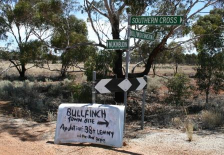
This roadside sign made us laugh, but we never spied Lenny!

As we travelled along the highway towards Coolgardie and Kalgoorlie, we entered the western edge of the 16 million hectare Great Western Woodlands, the largest remaining area of intact Mediterranean-climate woodland on Earth. It includes 20% of Australia’s eucalypt species – more than 160 species.  Being amongst larger trees meant that we were seeing more beautiful large birds such as Red-tailed Black Cockatoos, Pied Currawongs and Corellas.

Arrived in Kalgoorlie and did the usual setting up before hunting down Rex and Maureen, who were in the same caravan park.  Spent the evening catching up with them and sharing travel stories, which is always terrific.

Saturday and Sunday were lovely sunny days – ideal for exploring the beautiful Goldrush architecture of Boulder and Kalgoorlie.  The main street of Kalgoorlie, Hannan Street, has changed very little since its early days of construction and we took advantage of the excellent heritage walk audio tour of the town.  There was so much to see we had to spread it over the two days – we have been just astounded at these buildings and enjoyed wandering inside many of them, particularly the hotels, many of which were opulently decorated, with glorious staircases – no wonder it took us so long!


The dining room of The Palace Hotel


There were superb Jacarandas flowering all through Kalgoorlie and Boulder.


The York Hotel
 
A visit to the Super Pit Lookout is mandatory.  From here you look down into a massive hole carved into the earth (reputedly the largest in the world and visible from space) and watch trucks the size of houses, which look like Matchbox toys, carting tonnes of rock out of what is the richest square mile of gold-bearing earth in the world.


We joined Rex and Maureen for a tour of the Questa Casa brothel, one of the last three of what was many more, remaining in Hay Street.  It was very interesting indeed and the Madam, Carmel, was a total surprise – a very cultured and ‘proper’ lady who has owned the brothel for 20 years and shared some wondrous (and seriously creepy) stories with us!

 
The Bondage Room!!!!!!!!!!!!!

The 4km walk around Karlkurla Park, a 200 hectare showcase of the Great Western or Goldfields Woodlands, was an ideal opportunity to once again marvel at the plants of the region, as was a wander around the much smaller Kalgoorlie-Boulder Arboretum, which focused particularly on the eucalypts.

Gimlet
Salmon Gums
 
 
Eucalyptus woodwardii (Lemon Flowered Gum)
 
Eucalyptus torquata x woodwardii (Torwood)


It is now time to pack up once again and continue our trek east.  Tomorrow we will be in the Nullarbor – down to Norseman and a left turn towards the border, which we expect to reach by Wednesday.  Not sure when we will have internet connection again, so the next post will be whenever!